Commencing the Great Peruvian Divide

image

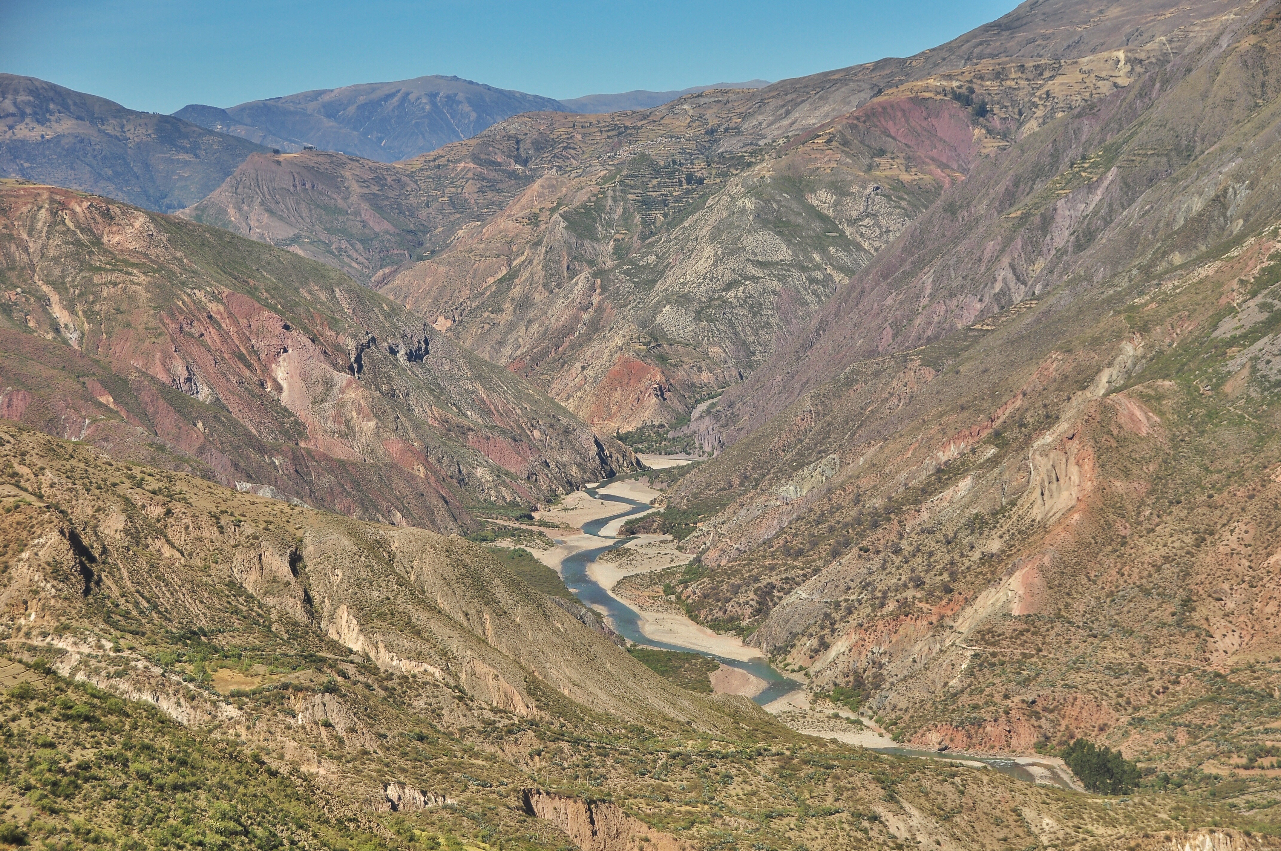
As we stopped to eat lunch at the top of our third and hardest pass yet we saw a few cows as well as a smiling traditionally dressed lady in her thirties coming up and over the other side. She was obviously surprised to see us “gringos” on this rarely used rocky mountainous road, and animatedly began asking us questions in Qetchwa. Once we explained that we only spoke Spanish, she smiled and then waved us over, motioning for us to bring over one of our plates to where she was opening up the large colorful blanket she carries as a bag on her back. She then scooped three huge scoops of, well, who knows what, from a steaming bucket full of white potato/quinoa/unknown grain/milk mush into our bowl before swinging her blanket back over her back in order to follow her cows back down the mountainside. Welcome to the Great Peruvian Divide; a network of small rocky roads which connect rural villages throughout the Andes where smiling toothless villagers stop to encourage you along your way as you fight for every kilometer as it’s always uphill.

Continue Reading…

Embarking on the Peruvian Divide: 1,500km of Mountainous Fun

image

After leaving Cusco, Kevin and I will embark on what is sure to be the most challenging, yet in all likelihood, the most rewarding part of our whole trip; The Great Peruvian Divide. I’ve been anxiously awaiting the beginning of this 35,000m elevation gain route – that’s like climbing Everest four and a half times from sea level to the top – since we first read about it on the Pikes on Bikes site. This route will take us up and over almost thirty high altitude pass (all around 5,000m) along a road which doesn’t appear on a single map (nor Google maps). We will pass through extremely rural villages where Quetcha, not Spanish, is the norm, and we will climb and descend passes which aren’t even possible for most cars.

Continue Reading…

Climbing Huyana Potosi: A Magnificent Sunrise at 6,088m

image

Sitting at the top of Huyana Potosi (6,088m/20,000ft), Kevin, John (an American cyclist we met in La Paz), our guide “Super Mario,” and I watched the world come to life. It was 6h30 and after five hours of climbing, we had made it to the top just in time to turn off our headlamps as the dark sky was beginning to glow. The clouds in the distance made the morning light appear bright orange and red before the sun finally hit our snowy cold vantage point. In front of us lay the cloud covered Yungas, and for as far as we could see behind us was the altiplano (including lake Titicaca). To our right the sprawling city lights of La Paz and El Alto shone bright, while to our left the other beautiful snow capped mountains which make up the Bolivian Cordillera Real stood majestically still. Climbing slowly up the mountain just a few hundred meters away were a few groups of other climbers who would arrive shortly and crowd this tiny summit, but for just a few more minutes, we would have it all to ourselves.

Continue Reading…

Coca Leaves And Rain: The Bolivian South Yungas

image

The north-eastern Bolivian region of the South Yungas is a composed of huge hills of almost-jungle-like hot and humid terrain where there are always birds a chirpin’, grasshoppers a hoppin’, and rain a fallin’. Though it’s an interesting and very friendly area full of small to medium sized villages atop various hillsides as far as the eye can see, the heat and humidity made the cycling miserable, because even though this is there “winter,” it’s still hot and sticky. Though the heat made us sweat like we haven’t since the hot summer in Georgia nearly a year ago, it did provide us with a variety of foods we weren’t able to find on the altiplano, notably the short and fat sweet bananas I call “Indian bananas” (as we ate them in India) and fresh passion fruit juice, as well as plantains which they served both raw and fried with every meal. Though some of the climbs were steep, we were able to cover ground reasonably fast as the ground was a rocky but not too bad unpaved surface, and as we were between 1,000m-2,500m most of the time, it was extremely easy to breath.

Continue Reading…

Switchbacks and Soccer Fields: Bolivian South Yungas Loop

image

This lush green route has become a highlight because the cycling is relatively easy, the villages are picturesque and friendly as there is virtually no tourism besides cyclists, and the scenery is so different than what we have previously experienced in Bolivia. The road, which is carved out of the mountainside, looks a whole lot like the Indian/Nepali roads throughout the foothills of the Himalayas, and the rushing rivers and towering green hillsides are a welcome change after so much sandy nothingness in the altiplano. After an easy morning ride we ended up spending the day and night in a typical quaint village before heading out the next morning for ten kilometers of steep switchbacks down to the river, and then a 1,000m evaluation climb up and over our second pass. We then continued down and up again (and then down and up again… flat isn’t a word which exists out here) until we found the only flat ground around, a soccer field which belonged to a cluster of a dozen or so houses which we hadn’t even been able to see from the road.

Continue Reading…

Passes and Canyons, Sun and Snow: Bolivian South Yungas Loop

image

After eighty fast kilometers on the not-very-busy, large shouldered highway, we came to the cut off which would bring us through a four-hundred kilometer route to La Paz (instead of going straight there on the 120km flat paved highway). This route will take us up a 4,800m pass before dropping all the way down to 1,000m as we cycle through the South Yungas region of northern Bolivia, after which we will have to climb all the way back up to 4,700m in order to head back onto the altiplano and into La Paz. In total this route will involve 10,000m of elevation gain, which, to put into perspective, is like climbing Everest from sea level all the way to the top… plus another 2,000m just for kicks. Needless to say, we have a whole lot of ups and downs to look forward to!

Continue Reading…

15$ of Luxury: Rest Days in Bolivia

Though I started out on this trip as an extreme minimalist; living on five dollars a day as I slept every single night in my tent and ate a whole lot of oatmeal and pasta, Kevin and I have decided to take a different approach to this last leg of our journey as we know that financially we are going to make it. We have decided that instead of always sleeping in our tent, we will start staying in hostels more often, and as the food in Bolivia is cheap, we will eat out whenever we please. Basically, we have thrown any notion of a budget out the window in order to fully enjoy our last few countries without restraint.

Continue Reading…

150km of Blinding White: Cycling The Salar de Uyuni

image

When I visited Bolivia’s largest salt flat (which is also the largest in the world) four years ago by jeep I had no idea that I would someday return to cycle across it. In fact, I didn’t even know that was possible. For the first seventy kilometers we had to share the Salar with tourist jeeps which would speed by, and then flicker out of existence in a weird optical illusion sort of way. It was funny to watch all of the tourists, who looked like tiny cartoon stick figures, taking pictures on the horizon, though we were happy to have our bikes and independence in order to explore at our own speed. We arrived to an island 100km from Uyuni where there were dozens of jeeps, and since this marked the end of the road for them, it was where the fun began for us as we crossed the rest of the Salar completely alone. It took us two full days to cross the Salar, 150km of salt and about 190km of pedaling from one town to the next.

Continue Reading…

Exploring a Bolivian Market

image

Bolivian (as well as Peruvian and Ecuadorian) markets are my favorite markets on earth, in fact, they are one of the many reasons that this whole continent far surpasses any other in my mind. As I don’t feel comfortable taking pictures of local people (I’ve had my picture rudely snapped many a times now, and know that the feeling of a trapped zoo animal is no fun), I’ll take you through a Bolivian market by words.

Continue Reading…

Village Life in the Bolivian Altiplano

image

The first Bolivian village we entered into was Quentena, which stands in the middle of nowhere at 4,200m surrounded by mines which make up its main economy. A looming nearby mountain has an old road all the way up to 5,700m (6,000m peak) where the highest mine in the world use to operate, and down in the village, women in the traditional Andean attire – stockings, a pleated skirt, and a colorful vest or shawl – watch us a bit curiously as we slowly cycle into town. Though everyone speaks castillano (Spanish) to us, they speak Quetchwa amongst themselves. We eventually find a small shop which sells crackers, cookies, and some clothes, and after buying a few snacks, we continue past a few dozen more mud brick houses until we are once again all alone in the mountains.

Continue Reading…